

LONG BEACH ISLAND – The bay spilled across roads and into garages and lower levels of homes. Boats broke loose from their lifts and drifted away without their owners. On the other side of the narrow barrier island, pounding surf carved away sections of dunes.
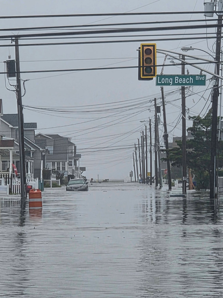
For residents who stayed on Long Beach Island through the weekend nor’easter, the storm was measured less by rainfall totals and wind speeds than by what they could see outside their windows. Long Beach Boulevard disappeared beneath several feet of water in some places, vehicles were moved toward the ocean in search of higher ground and kayaks became a way to check on neighbors.
The flooding became severe enough that authorities closed the Route 72 Causeway for an extended period, temporarily cutting off the island’s only roadway connection to the mainland. Ocean County Sheriff Michael Mastronardy said county officers worked closely with the island’s police chiefs, assisting with traffic, escorts, disabled vehicles and other needs. “Everybody worked in concert, so it was good teamwork,” Mastronardy said.
A Storm That Wouldn’t Leave
The length of the storm was a major reason its effects became so pronounced, according to Matthew Janssen, a research assistant professor at Stevens Institute of Technology and assistant director of the New Jersey Coastal Protection Technical Assistance Service.
Preliminary data indicated storm surge of about three feet, Janssen said. At the same time, the weekend full moon produced tides approximately six inches to a foot higher than normal. Together, the surge and tide pushed water levels roughly four feet above normal high tides. Janssen said the timing of the storm with the full moon contributed to the widespread impacts.
Duration compounded the problem, Janssen said. During a long nor’easter, each high tide brings more water into the bay before the previous tide has had enough time to drain. “You can think of it as trying to drain a sink where the drainpipe is already full of water,” Janssen said.
Based on Stevens’ Storm Erosion Index, Janssen said the event’s duration “ranks within the top five storms in LBI since 1980.” Its peak intensity was lower than Sandy, Janssen said, but its prolonged duration ranked just below several notable storms, including the December 1992 nor’easter and Veterans Day storm of 2009.
Watching The Boulevard Disappear
Steve Helewa watched that process unfold from his home on Long Beach Boulevard in Brant Beach. Water began reaching the Boulevard around 9:30 p.m. Friday, he said, and within about an hour the roadway was submerged. It remained underwater at varying depths through much of the weekend.
At its highest, Helewa estimated water along the curb reached three-and-a-half to four feet. His building escaped interior flooding, although water came within about six inches of the first-floor business entrance. Across the Boulevard, it reached garages and driveways.
Garbage cans and debris floated past. A commercial dumpster traveled through the neighborhood before coming to rest against the porch at Daddy O, while a kayaker paddled through the flooded streets checking on neighbors and even Helewa’s vehicle, which had been moved toward the ocean.
Boats Lifted From Their Lifts
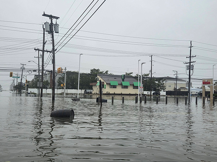
Near 21st Street and Waverly Avenue, Tom DeMartin was at his mother’s house and watched two neighboring boats break loose from lifts during the rising tide. “You put these boats up on a lift because you don’t ever expect the bay to get that high,” DeMartin said.
One boat eventually reached Fifth Street Bay Beach, while another became lodged near a marina before being recovered Sunday. At DeMartin’s mother’s home, the garage and lower vestibule flooded, with water reaching the third step leading toward the elevated living area. “We’re kind of used to flooding on the island, but nothing like this,” he said.
Cut Off From Mainland
The Causeway closure added another challenge. Mastronardy said it remained closed for an extended period as authorities dealt with dangerous conditions and motorists becoming stranded. High-water rescue vehicles were available if anyone needed to be evacuated for a medical emergency, although he was unaware of any major evacuations.
One assist involved a Marine from California who had come to LBI for a wedding. Mastronardy encountered him after he crossed the first bridge on foot trying to reach the celebration. When the sheriff’s vehicle could go no farther because of the flooding, officers in a high-water vehicle got the Marine to the wedding.
The next day, Mastronardy spotted him again, this time with his sister and a suitcase, trying to return to his car. Sheriff’s officers helped them back across so he could begin his trip home to California.
“I hate keeping people from their homes or from leaving, but it’s for their own safety,” Mastronardy said, pointing to the number of motorists who became stuck.
Water Came Up Fast
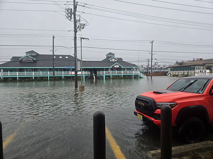
In Beach Haven Terrace, Doug Easterly experienced how quickly conditions changed. Easterly has owned his property near 129th Street and Indiana Avenue since 1999. During Sandy, approximately two feet of water entered the home, which ultimately had to be stripped to the studs.
This time, Easterly was inside Saturday morning when he looked out around 9 a.m. and saw water suddenly lapping against his front porch. “Holy cow, where did this come from?” he remembered thinking.
By Sunday, water still surrounded his home. He had moved his car toward the dunes and eventually walked barefoot through receding water to retrieve a pair of galoshes from the vehicle. “Most people, honestly, are hibernating in their houses,” he said.
The Power Of Waves
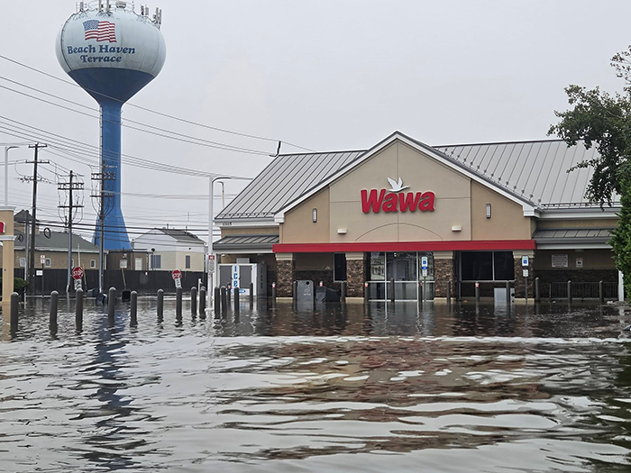
Vehicles moving through flooded streets created another concern. Janssen, the researcher, said their wakes can exceed six inches, potentially pushing water into homes and garages already on the verge of flooding.
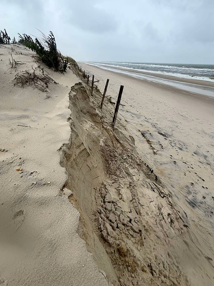
While the bay inundated neighborhoods, the ocean was reshaping the other side of the island. Helewa photographed a sharply eroded dune at 41st Street in Brant Beach, saying it appeared that half of it was gone.
Janssen said elevated water, wave height and duration are the three primary drivers of beach erosion. Wide beaches and large dunes provide considerably greater protection, while dunes behind narrow beaches are more vulnerable. Stevens’ research has found that halving beach width can increase the risk of dune failure fourfold.
Despite inevitable comparisons, Janssen cautioned against equating the storm with Sandy. Sandy produced historic peak water levels and wave heights over a comparatively short period. This nor’easter was distinguished by its persistence.
“While peak water levels and wave heights are lower than Sandy, many residents are dealing with multiple days of flooding rather than a single dramatic peak,” Janssen said. “Cumulative effects can be substantial even when peak conditions are lower.”
For residents, the next stage begins as the water recedes. Janssen said officials will need to document flooding and structural damage, beach and dune erosion, debris and changes to navigation channels to understand the storm’s full impact.
The post VIDEO: Nor’easter Batters LBI From Bay To Beach appeared first on Jersey Shore Online.